Collet d'Allevard seven-day paragliding activity forecast
Country: FR. Coordinates: 45.389923, 6.120826. Altitude: 1500 metres.
Site tags: Alps, Belledonne, car, Collet d'Allevard, Grésivaudan, lift, mountains, official, shuttle.
The forecast shows the chance of any recorded flying activity and the chance of flights reaching progressively higher point thresholds. Higher values indicate more promising historical flight patterns, not guaranteed flying conditions.
| Date | Chance of a flight | Chance of a 10+ point flight | Chance of a 20+ point flight | Chance of a 30+ point flight | Chance of a 40+ point flight | Chance of a 50+ point flight | Chance of a 60+ point flight | Chance of a 70+ point flight | Chance of an 80+ point flight | Chance of a 90+ point flight | Chance of a 100+ point flight | Forecast computed | Weather forecast cycle |
|---|---|---|---|---|---|---|---|---|---|---|---|---|---|
| 2026-09-15 | 71% | 60% | 44% | 31% | 22% | 16% | 11% | 8% | 6% | 4% | 3% | 2026-09-15T10:16:55.065296 | 2026-09-15T06:00:00 |
| 2026-09-16 | 9% | 3% | 1% | 0% | 0% | 0% | 0% | 0% | 0% | 0% | 0% | 2026-09-15T16:17:05.192182 | 2026-09-15T12:00:00 |
| 2026-09-17 | 41% | 27% | 15% | 9% | 5% | 3% | 2% | 1% | 1% | 1% | 0% | 2026-09-15T16:24:27.652520 | 2026-09-15T12:00:00 |
| 2026-09-18 | 28% | 19% | 11% | 6% | 4% | 2% | 2% | 1% | 1% | 0% | 0% | 2026-09-15T16:31:07.486700 | 2026-09-15T12:00:00 |
| 2026-09-19 | 57% | 43% | 28% | 17% | 10% | 6% | 4% | 3% | 2% | 1% | 1% | 2026-09-15T16:37:32.250067 | 2026-09-15T12:00:00 |
| 2026-09-20 | 35% | 21% | 10% | 4% | 2% | 1% | 1% | 0% | 0% | 0% | 0% | 2026-09-15T16:44:07.479051 | 2026-09-15T12:00:00 |
| 2026-09-21 | 11% | 4% | 1% | 0% | 0% | 0% | 0% | 0% | 0% | 0% | 0% | 2026-09-15T16:51:21.858296 | 2026-09-15T12:00:00 |
| 2026-09-22 | 30% | 17% | 8% | 4% | 2% | 1% | 1% | 0% | 0% | 0% | 0% | 2026-09-15T16:58:03.887623 | 2026-09-15T12:00:00 |
Collet d'Allevard planning context
The following tables and links are semantic alternatives to the interactive season chart, site map, resource tabs, atmospheric profile and similar-days panels.
XC0 monthly seasonality
| Month | Average qualifying days |
|---|---|
| January | 2.6 days |
| February | 4.4 days |
| March | 5.0 days |
| April | 6.2 days |
| May | 9.2 days |
| June | 8.6 days |
| July | 14.4 days |
| August | 15.2 days |
| September | 8.8 days |
| October | 5.2 days |
| November | 4.2 days |
| December | 2.0 days |
Collet d'Allevard takeoff and landing spots
Takeoffs
- Malatrait: 45.393688, 6.106711; altitude 1400 m; suitable wind W-NW.
- Déco: 45.392372, 6.115248; altitude 1560 m; suitable wind S-SW.
- Super Collet: 45.391485, 6.124201; altitude 1680 m; suitable wind NW-N.
- Collet d'Allevard Speedriding: 45.393907, 6.139853; altitude 1865 m; suitable wind SW.
- Les Plagnes: 45.385738, 6.147681; altitude 2050 m; suitable wind SW.
Landings
- Pre Rond: 45.422125, 6.091633; altitude 405 m.
- La Mirande: 45.412571, 6.086625; altitude 405 m.
- Super Collet: 45.392048, 6.127994; altitude 1660 m.
Validated local resources
- Local resource: Le Collet
- Local resource: Coccin'ailes
- Local resource: Alpes Isère
- Local resource: Allevard-les-Bains Tourist Office
- Local resource: Fédération Française de Vol Libre (FFVL)
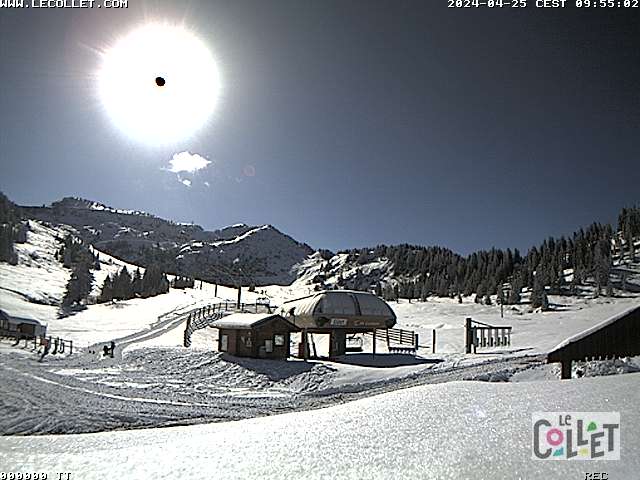
- Webcam: https://webcams.lecollet.com/imageSC.jpg
- Webcam: https://www.alpes-isere.com/webcams/#overlay-sit
Resource extraction updated: 2025-11-09T12:41:44.877241.
This information supports planning and historical comparison. It is not a safety guarantee; verify current conditions, airspace and local rules before flying.
Collet d'Allevard
